
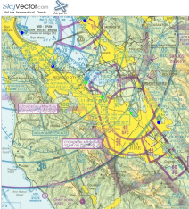
 Recently someone pointed me at SkyVector.com which can most easily be described as "the Google Maps of Aviation." They've taken the aviation sectional charts for the entire USA, scanned them, broke them up into square "tiles", and provide a smooth click-and-drag panning interface for navigating the maps.
Like Google maps, you can zoom in and out, drag around, and quickly get a feel for what's there. And there's some overlay data too. They overlay graphics for all known airports. You can click on one to get a detail page. For example, the page for Reid-Hillview in Santa Clara County.
There's currently no provision (that I can find) for overlaying custom user data (waypoints from a GPS would be an obvious starting point). However, they do make it easy to embed a small map in a web page, linking back to SkyVector. Perhaps an ex-SEO designed this? :-)
I think the ultimate combination would be the ability to pull in and overlay real-time and forecast weather data and maybe even Google Maps road or satellite images. But even without that stuff, the site is very useful. Paper aviation sectional maps can be a pain in the ass. They're always folded in all the wrong places. I've long wanted the ability to order custom-printed sectionals where I specify the map center and size. Heck, if the government was to simply put up high-resolution maps or vector graphics files, someone would probably build it.
Until then, we've got SkyVector.
Posted by jzawodn at January 14, 2006 09:04 AM | edit
This is awesome - basic flight research should be so much easier now. Of course with the ADIZ and TFR crazyness that we live in today having current charts are still a must.
I've got a parallel effort going on at aerowx.com .
Good website for terrorists. Google Maps and Sky Vector provide a great public service. As for Sky Vector, shouldn't that site only be accessable to folks who already fly planes, than people who might not be able to fly, but might want to fly some planes into buildings and landmarks? I guess the U.S still haevn't learn the lessons of 9/11 to further prevent more folks from launching attacks against U.S interests.
[quote]Heck, if the government was to simply put up high-resolution maps or vector graphics files, someone would probably build it.[/quote]
I wonder why the government aren't doing that. Something to do with terrorism perhaps? Just a guess.
I guess the 9/11 folks didn't have Google Earth and Sky Vector to plan their attacks. I guess allowing this sort of information to be accessable to *everyone* won't make much difference if someone is determined to fly planes into buildings and landmarks.
Uh, what are you smoking?
You think the government should just start banning maps now?
Very cool. With this and PDF approach charts at airnav, the Internets is just so damn useful.
This is great, thanks for pointing the site out. I've been a fan of myairplane.com for a few years now, but they haven't been able to keep up with the integration of seamless scrolling and zooming. I have a new favorite now! Now, how about some low altitude enroute charts???
Wow, this is fantastic! I love it. Virtual VFR is coming.
Ref: "Paper aviation sectional maps can be a pain in the ass"
Ha! In 1976 I flew a Colt CT-Catalina-CT, then in 1982 (apparently having not learned a lesson) flew my 182 from Los Angeles to Alaska, then to Denver, then back to L.A.
I recall every day (both trips) spending lots of time "folding maps" which was OK until a wx divert then "cockpit mayhem".
Wow what a godsend the e-maps are... Thanks!
Have a look at
The website went online yesterday evening. There you will find not only dragabble sectionals, but also live satellite and radar images, METARS, and a birdview photo provided by google maps. I hope you like it. It is brand new and there might still be some problems - let me know if something does not work for you. I am very interested to get your feedback ( info@flyagogo.net ).
Just a comment on the gvt. restricting information.
Anybody can get the paper maps. Besides, if the terrorists were already ENROLLED IN A FLIGHT SCHOOL, do you think that internet would deter them?!? Besides, there are many other ways to wreak havoc. Aviation isn't so easy anymore, and especially not General Aviation... terrorists can accomplish much more with a U-Haul parked in the middle of a city...
Gears Down (gearsdown.com) is another site that has online aeronautical sectionals, and you can switch between other maps (like a road map) once you find your airport.
The maps are stitched together as one complete map and it uses Google Maps to display them. It also provides weather info, like METAR/TAF, and route marking/planning.
SkyVectors is a really handy tool when you're on the ground, but I've been wishing for a more convenient way to manage sectionals charts in the air. I recently ran across someone who'se formatting sectionals for kneeboards--it's a great solution. You download the sectional and can print it out youself--each sectional is diced up into standard letter-sized panels. They fit on my kneeboard perfectly, the price is less than a printed sectional and they're much more convenient.
Their URL is http://www.skysecitionals.com
Love the site, but.. every once in a while the heli chart links disappera (the links at the top right of the window showing other charts) along with the flight planning tool. I use the flight planner often. In the past I've been able to reset my IE Browser to factory settings and the problem seemed to disappear, but now that doesn't work either. Any ideas what could be causing this? It does the same thing on my lap top as well. thanx
Hi
Good afternoon,
I would like to link or copy the code of an airport (for example KSMO) and then paste it in my website, it is possible? Can you show the way and with google too.
Thank you
Norland